Vanuatu is one of the most vulnerable countries in the world to climate change and disaster risks.
The country experiences cyclones, storm surges, landslides, flooding and droughts, which may become more intense and less predictable in the future due to climate change.
In the last two years alone, Vanuatu has been affected by several cyclones, an El Niño drought to name a few hazards. Many communities have traditional or new coping mechanisms against natural disasters built in and are quite resilient already. However, in urban areas, communities often lose access to their traditional knowledge and coping mechanisms, contributing factors affecting this could be living in more cramped areas, without land for gardens and possibly even a less rigid leadership structure.
So how does climate change affect the day to day lives of communities? In Luganville it is evident in the acceleration of coastal erosion on the main road by the new and old wharves, business district, and la plaçe. The areas of Pepsi at the shores of Sarakata River also experience a lot of flooding.
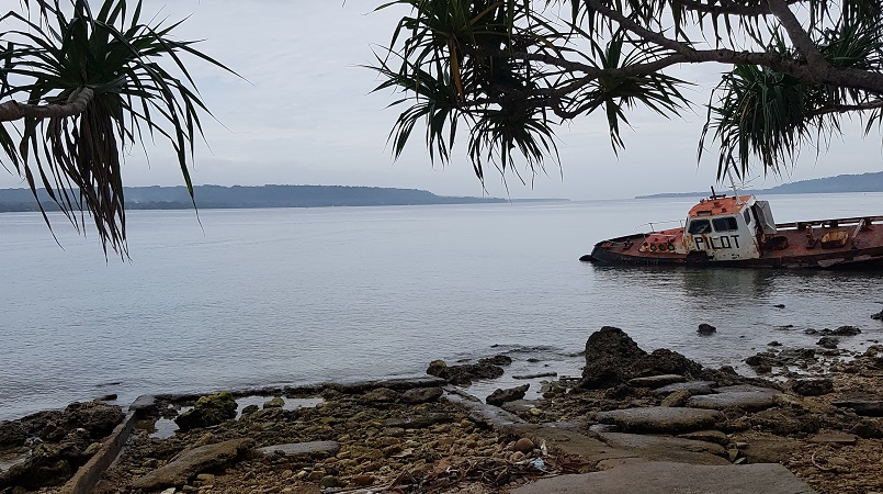
According to the International Climate Change Adaptation Initiative the sea level has been rising an average of 6mm every year in Vanuatu waters since 1993. This is almost double the global average. The assistant Harbour Master in Luganville pointed out the old barge pictured to the Vanuatu Red Cross team and mentioned that only 5 years ago it was on dry land and now it is beyond 5 meters out in the canal. Where will the businesses and services that are close to the canal be in 10 years?
The Vanuatu Red Cross team has created a special working group under the SANMA Provincial Disaster Committee to carry out mapping of the effects climate change will have on Luganville and its communities. The mapping is expected to take place before Christmas and contribute to the Province and Municipal Council plans.
Photo supplied