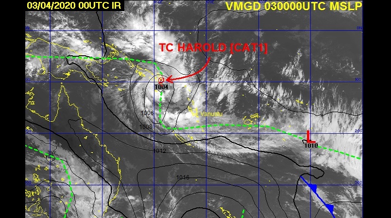
The Vanuatu Meteorology and Geo-hazards Department says the potential for Tropical Cyclone Harold to intensify further and moves towards Vanuatu in the next 24 to 48 hours is high.
At 11am local time, Tropical Cyclone Harold (990hPa) Cat1 moved into Vanuatu's area of responsibility and was located near 10.8S 161.1E. Tropical Cyclone
The latest alert said Harold is positioned at the bottom left of square letter A of the Vanuatu Tropical Cyclone Tracking Map.
This is about 195KM southeast of Honiara. In the past 6 hours, the system was moving in an east southeasterly direction at 34KM/HR.
Gale force winds of 70KM/HR increasing to 90KM/HR are expected within 85 Nautical miles from its centre.
Rainfalls will become heavy with possible flash floods over low lying areas, areas close to the river banks including coastal flooding expected to affect the
Vanuatu group today and continuing tonight. Seas will also become very rough with heavy swells as the system continues to move east southeastward.
A Severe weather warning is current for Vanuatu group.
People, including sea going vessels are advised not to go out to sea.
The Vanuatu Meteorology and Geo-Hazards Department is closely monitoring the system and will issue the next information at 6pm (local time) or earlier if the situation changes. People are advised to listen to Radio Vanuatu and all other radio outlets to get an update information on Tropical Cyclone Harold.
Photo Vanuatu Meteorology and Geo-Hazards Department