Vanuatu's largest island, Santo, is bracing for a direct hit from a powerful cyclone that is due to make landfall this evening, with winds near its centre gusting as strong as 235km/h.
Cyclone Harold - a category five, the highest possible - has sat just to the west of Vanuatu's central islands for much of the past day, gathering significant strength in the past 12 hours.
Fred Jockley, a managing forecaster at the Vanuatu Meteorological Service, said this storm was the most serious since Cyclone Pam, which destroyed much of the country in 2015, killing few people, but setting livelihoods, infrastructure and the economy back years.
Mr Jockley said Harold was displaying the signs no one wanted to see: it had effectively stalled, moving as slow as two knots, which allows it to suck up moisture from the warm ocean and gain ferocity; it was growing in size, and its force would likely envelop much of Santo and Malekula, Vanuatu's two largest islands; and its current track had it skirting very close to Luganville, the country's second-largest city with more than 16,000 people.
Current forecasts had it passing close by at 5pm, local time (6pm NZT).
"It's very slow now. It's been very slow the past six hours, but now it's beginning to pick up speed," Mr Jockley told RNZ Pacific. "It's going to go through Santo and Malekula."
"The winds range is covering the whole of Santo and part of northern Malekula."
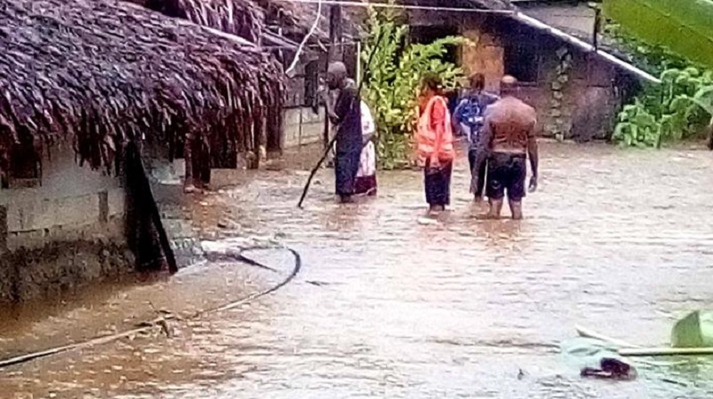
Mr Jockley said there were already reports of widespread flooding across the country's central provinces. On Santo, officials had evacuated residents from villages along one of the island's main rivers as it burst its banks. The official number of people in evacuation centres is so far unknown.
Fred Jockley, a managing forecaster at the Vanuatu Meteorological Service, said this storm was the most serious since Cyclone Pam, which destroyed much of the country in 2015, killing few people, but setting livelihoods, infrastructure and the economy back years.
Mr Jockley said Harold was displaying the signs no one wanted to see: it had effectively stalled, moving as slow as two knots, which allows it to suck up moisture from the warm ocean and gain ferocity; it was growing in size, and its force would likely envelop much of Santo and Malekula, Vanuatu's two largest islands; and its current track had it skirting very close to Luganville, the country's second-largest city with more than 16,000 people.
Current forecasts had it passing close by at 5pm, local time (6pm NZT).
"It's very slow now. It's been very slow the past six hours, but now it's beginning to pick up speed," Mr Jockley told RNZ Pacific. "It's going to go through Santo and Malekula."
"The winds range is covering the whole of Santo and part of northern Malekula."
Mr Jockley said there were already reports of widespread flooding across the country's central provinces. On Santo, officials had evacuated residents from villages along one of the island's main rivers as it burst its banks. The official number of people in evacuation centres is so far unknown.
12:20pm: Hundreds in evacuation centres, Santo braces for impact
Vanuatu's second town of Luganville is normally a bustling port town on a crystal bay at the southern end of the country's biggest island, Santo. On Tuesday it sat abandoned, shops closed, houses boarded up, the sky a thunderous black, the sea a choppy grey.
Kensley Micah, the lead disaster official for Sanma province, which includes Luganville, said the island was bracing for a direct hit from Cyclone Harold later on Monday evening, and hundreds across the province had already sought shelter in evacuation centres.
As he spoke to RNZ Pacific from Luganville, a town of 16,000 people on Monday morning, Mr Micah said conditions were deteriorating rapidly.
"The wind is very strong this morning and getting stronger, with rain. All shops in towns are closed. We also have electricity cut off, and we have water cuts everywhere," Mr Micah said.
"Luganville now is facing a lot of challenges."
Things were already in tough in Santo. The island has been lashed by torrential rain for days, as the cyclone crawled closer, and then stalled about 100km off the western coast. Already, crops have been washed out and roads cut off. There were concerns fresh water supplies had been tainted.
Overnight, hundreds of people sought shelter in evacuation centres as some of the island's larger rivers burst their banks, flooding houses. "There's more rain, there's a lot of flooding in the low-lying area," Mr Micah said.
He said he couldn't give a figure on how many people were in evacuation centres, as communication with rural areas outside of Luganville was proving difficult. An official at the Vanuatu Red Cross, Augustine Garae, told RNZ Pacific it could be as many as 1,000 people.
"It's really hard to get into the rural areas," Mr Micah said. "There is flooding everywhere, with roads blocked and things like that. We have communication problems; we can't get in touch with people from the area councils. Right now, we don't get any information from the rural communities."
For now, it was a case of hunkering down and waiting out the storm, which was due to make landfall in Santo at 5pm, with winds near its centre gusting as high as 235km/h. The whole 4,000-square kilometre island would experience winds well in excess of 120km/h.
As soon as that passed, Mr Micah said his teams were ready to mobilise. But it's likely help would be needed.
"From my opinion, it looks like most people will lose their food crops, so I think the government might have to step in to provide some kind of food supply."